空间索引#
Spatial indexes
空间数据库的一个重要特点是能够创建特殊的空间索引,以加速基于几何形状的搜索。这些索引用于执行空间操作,例如识别位于给定边界框内的所有要素、识别离给定点一定距离内的所有要素,或识别与给定多边形相交的所有要素。
空间索引的定义与定义普通数据库索引的方式相同,不同之处在于添加了 SPATIAL 关键字,以将索引标识为空间索引。例如:
CREATE TABLE cities (
   id   INTEGER AUTO_INCREMENT PRIMARY KEY,
   name CHAR(255),
   geom POLYGON NOT NULL,

   INDEX (name),
   SPATIAL INDEX (geom))
在本章中我们将介绍的所有三种开源空间数据库,都是使用 R-Tree 数据结构来实现空间索引的。
备注
PostGIS 使用 PostgreSQL 的 Generalized Search Tree (GiST) 索引类型来实现 R-Tree。尽管在 PostGIS 中使用 GIST 类型来定义空间索引,但它们在内部仍然作为 R-Tree 来实现。
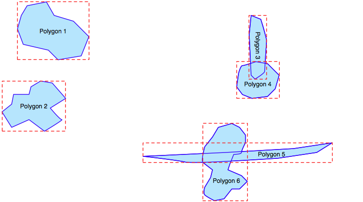
R-Tree 索引是空间数据库最强大的功能之一,值得花些时间了解它们的工作原理。R-Tree 使用 最小边界矩形 来表示每个几何图形,允许数据库通过几何图形在空间中的位置快速搜索:
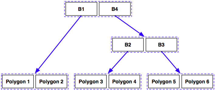
这些边界框根据它们之间的相对位置被分组为嵌套的层次结构:

这个嵌套的边界框层次结构随后通过类似树的数据结构来表示:
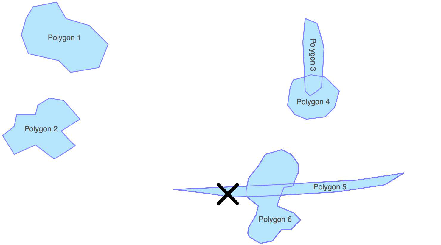
计算机可以通过遍历这个树结构来快速找到特定的几何图形,或者比较不同几何图形的位置和大小。例如,假设我们想找到与以下点相交的多边形:
数据库可以通过遍历树并比较每一层的边界框,快速找到这个几何图形。R-Tree 将以以下方式进行搜索:
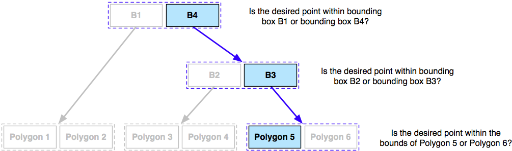
使用 R-Tree 索引,仅需要三次比较就能找到所需的多边形。
由于树结构的层次特性,R-Tree 索引的扩展性非常好,能够通过极少的边界框比较,快速搜索数以万计的要素。而且,由于每个几何图形都简化为一个简单的边界框,R-Tree 索引可以支持任何类型的几何图形,而不仅仅是多边形。
R-Tree 索引不仅限于搜索封闭的坐标;它们可以用于各种空间比较以及空间连接。我们将在下一章中广泛使用空间索引。
One of the defining characteristics of a spatial database is the ability to create special spatial indexes to speed up geometry-based searches. These indexes are used to perform spatial operations such as identifying all the features that lie within a given bounding box, identifying all the features within a certain distance of a given point, or identifying all the features that intersect with a given polygon.
A spatial index is defined in the same way as you define an ordinary database index, except that you add the SPATIAL keyword to identify the index as a spatial index. For example:
CREATE TABLE cities (
    id   INTEGER AUTO_INCREMENT PRIMARY KEY,
    name CHAR(255),
    geom POLYGON NOT NULL,

    INDEX (name),
    SPATIAL INDEX (geom))
All three open source spatial databases we will examine in this chapter implement spatial indexes using R-Tree data structures.
备注
PostGIS implements R-Trees using PostgreSQL’s Generalized Search Tree (GiST) index type. Even though you define your spatial indexes in PostGIS using the GIST type, they are still implemented as R-Trees internally.
R-Tree indexes are one of the most powerful features of spatial databases, and it is worth spending a moment becoming familiar with how they work. R-Trees use the minimum bounding rectangle for each geometry to allow the database to quickly search through the geometries using their position in space:
These bounding boxes are grouped into a nested hierarchy based on how close together they are:
This hierarchy of nested bounding boxes is then represented using a tree-like data structure:
The computer can quickly scan through this tree to find a particular geometry, or to compare the positions or sizes of the various geometries. For example, imagine that we want to find the polygon that intersects the following point:
The database can quickly find this geometry by traversing the tree and comparing the bounding boxes at each level. The R-Tree will be searched in the following manner:
Using the R-Tree index, it took just three comparisons to find the desired polygon.
Because of the hierarchical nature of the tree structure, R-Tree indexes scale extremely well, and can search through many tens of thousands of features using only a handful of bounding box comparisons. And because every geometry is reduced to a simple bounding box, R-Trees can support any type of geometry, not just polygons.
R-Tree indexes are not limited to only searching for enclosed coordinates; they can be used for all sorts of spatial comparisons, and for spatial joins. We will be working with spatial indexes extensively in the next chapter.